The Music Department will be presenting their annual day long World Music Festival on Tuesday, April 27 (today!). There will be 10 groups and 2 solo artists performing music from various parts of the world.
Here is the schedule for the entire day:
Daytime performances at CRIMSON HALL (NOT RCC FOUNTAIN AREA):
1. The Lindsays (Traditional Irish Duo) 11 PM
2. Hot Tamale Brass Band (New Orleans Jazz) 12 PM
3. Annaliva (Traditional Irish Band) 1 PM
4. Veronica Nobles and her Mariachi Band (Mexican Music) 2 PM
5. BSC Chamber Singers (Western Classical) 3 PM
6. Jason Roseman (Trinidadian and Caribbean Music) 3:30 PM
7. The Bohemian Street Chanters (A capella Ensemble) 4:15 PM
8. The Male Bonding Band (Old Timey American Folk Music) 4:30 PM
(MBB includes Dr. Hayes-Bohanan and Dr. Domingo, though Dr. Domingo will not be available today.)
Evening performance (in Horace Mann Auditorium, Boyden Hall):
1. Khakatay (BSC West African Drumming Ensemble) 7:30 PM
2. Alley Cats (All Women American Barbershop Quartet) 8 PM
3. Marcus Santos and his Brazilian Ensemble 8:30 PM
Admission is free for all performances. Refreshments will be provided during the daytime performances.
The festival is in aid of building a school in Sierra Leone, West Africa. Donations will be welcome.
Tuesday, April 27, 2010

Monday, April 26, 2010
Internship: Massachusetts Broadband Institute - Westboro
The Massachusetts Broadband Institute (MBI) Summer Intern will assist with a wide variety of tasks associated with the mission to bring affordable, high-speed broadband Internet access to the unserved areas of the Commonwealth of Massachusetts. The Summer Intern will work closely with MBI staff to assist in all program activities including broadband infrastructure deployment, GIS mapping and data collection and community outreach.
Saturday, April 10, 2010
Annual Coffee Tasting
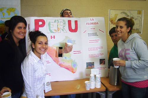
Coffee is the second-most traded commodity in the world (after oil), and in the past 1500 years, it has spread from its origins in Ethiopia to production areas throughout the tropics, mostly in former colonies of European countries. Coffee is an excellent way to learn about the world, and where the commodities we take for granted come from. It is for this reason that the department offers two classes on coffee - a study tour to Nicaragua and a second-year seminar.
The students shown above are demonstrating that coffee comes FROM some place, in this case Peru. The annual coffee tasting has now become a focus of the Second-Year Seminar the Secret Life of Coffee, which will be held on Tuesday, April 20 from 1 to 3 p.m. The event is free and open to the public, and will be held in the campus center ball room, along with the Just Trade Fair.
Posters will focus on particular countries or on topics such as coffee preparation and marketing. Decaf will be available. See the event page for more details.
Wednesday, April 7, 2010
Public Lecture on Henry David Thoreau
Jeffrey S. Cramer, Curator of Collections at the Thoreau Institute and editor of several editions of Thoreau’s works, will speak on “Living Deliberately: Thinking like Thoreau Today” on Tuesday, April 13th, from 3:00-4:30 in the Bridgewater Dining Room in the Campus Center of Bridgewater State College. Please feel free to bring classes and encourage students to attend. (NOTE VENUE CHANGE)
Wednesday, March 17, 2010
Acid rain monitoring volunteers -- April 11
Dr. Clark recently received this message from Water Resources Research
Center, University of Massachusetts, requesting help in an environmental monitoring project.. Please see the contact information below if you are able to participate.
We need your help. There are several sites that still need volunteers for ARM Sunday, April 11th, 2010 throughout Massachusetts. It's a great way to explore Massachusetts water bodies and help with valuable research at the same time.
What does sampling entail? We will send you a sampling bottle with instructions on how to get to your site and how to collect the sample, and then you will deliver the sample to the nearest volunteer sampling lab. That's
it! Please contact Beckie Finn, esfinn AT tei.umass.edu, 413.545.5979, for a list of sites that need coverage.
What does sampling entail? We will send you a sampling bottle with instructions on how to get to your site and how to collect the sample, and then you will deliver the sample to the nearest volunteer sampling lab. That's
it!
The Acid Rain Monitoring Project (ARM) began at the Water Resources Research Center, University of Massachusetts, in 1983. The project's mission was initially to develop a comprehensive picture of the sensitivity of Massachusetts surface waters to acid deposition, and later evolved to determine long-term trends in this sensitivity.
Our database represents the full water chemistry record beginning with the start of the project in March 1983. Samples were collected monthly in 1983 and 1984, semiannually in 1985 and 1986, and quarterly from 1986 to 1993. Current samples are collected semiannually. More than 40,000 records from nearly 5,600 lakes and streams are contained in the database. For more information, visit our website: http://www.umass.edu/tei/wrrc/arm/index.html
Thursday, March 11, 2010
Morocco field course -- Oklahoma State
The Cultural and Natural Resources of Morocco
GEOG 4910/5510 (3 credit hours, undergraduate and graduate credit options)
Oklahoma State University
May 22 to June 6, 2010
This study abroad summer course, offered through Oklahoma State University, College of A&S Outreach, will focus on themes of cultural and natural resources in Morocco and include fascinating and exciting experiences along the way. The course instructors are Dale Lightfoot and Thomas Wikle, both in the Department of Geography at OSU. Dr. Lightfoot has more than 15 years of experience with research and outreach projects in Morocco and the wider Middle East and North Africa region. His co-instructor, Dr. Wikle has traveled throughout North Africa and the Middle East and has directed more than a dozen summer travel courses since 1994.
The cost of the trip will be $4,181 for undergraduate students and $4,251 for graduate students and non-credit participants.
For more information please contact Tom Wikle (t.wikle@okstate.edu or 405 744-7978).
Conservation Conference - March 27 - student rates
Governor Deval Patrick will be the featured speaker at this year's Massachusetts Land Conservation Conference on March 27 in Worcester! The daylong conference, cosponsored by The Trustees of Reservations' Putnam Conservation Institute and the MA Land Trust Coalition, will also feature 30+ workshops on topics ranging from fundraising to land protection and management.
A complete list of workshops and registration information is available at www.massconservation.org. You can still get the early-bird rate of $42 if you register by March 12 (afterwards it's $62; student rate, $20). Have questions or want to volunteer? Email pci@ttor.org or call 978.840.4446 x1905.
Although Dr. Hayes-Bohanan is not attending this year, he has done so many times in the past, and can attest to the value of this conference for learning and networking. You are quite likely to see some of our alumni there as well!
Bizarre Map Challenge
The Bizarre Map Challenge is a map design competition open to high school, college, and university students in the United States. The goals of this challenge are: to promote spatial thinking; increase awareness of geospatial technology; and inspire curiosity about geographic patterns and map representation in students and the broader public. “Bizarre” in this competition refers to maps that are strikingly out of the ordinary. Though all maps must use real-world data, successful entries might employ unusual techniques, illustrate bizarre topics, or exhibit striking patterns.
All entries must be submitted in a static PDF format (no interactive or animated maps) using the on-line registration form. The complete map should be no larger than 8.5 x 11 inches (letter size) with a minimum of half-inch margins. A summary description, 500 words maximum, will also be required at the time of submission. The summary should describe why this map is bizarre, how it was created, the tools used, data sources, coordinate systems, projection methods, etc.
This competition is supported by the National Geospatial Technology Center and San Diego State University and prizes will be awarded to the top entries as voted on by a round of judges and then by the public. The First Place prize is $5,000.
Map submissions are due March 22.
Row for Water nearing the shore
Hundreds of students in our department's EarthView program have been impressed by the effort of Katie Spotz to raise money for fresh water by rowing across salt water. She left Dakar in early January in a row boat, armed with a lot of geographic knowledge. She will be arriving in Georgetown, Guyana soon, and is looking for donors to support her cause. Read more on our EarthView blog posting about nearing the shore, which has links to Katie's story, her maps, and donation tools.
Subscribe to:
Posts (Atom)